Maven 3.11 – New Drones Supported

This update is focused on supporting new drones
-DJI Mini 2
-DJI Air 2S
-DJI Mini SE

All functions of the app are available with the new drones

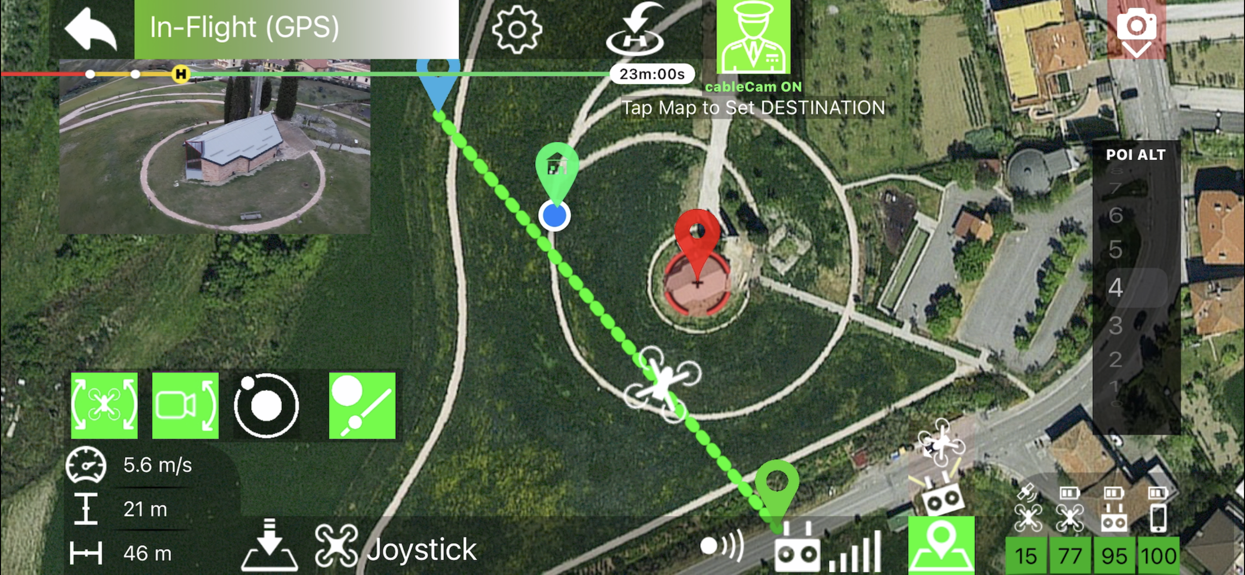
Added on-screen Exposure Lock Button 

Small bug fix and performance improvements

For sure this is the most anticipated update ever, Mini 2 owners are so many! and this puts us in front of a huge amount of new potential customers that we already welcome.

We are really excited about this update but it doesn’t stop us from working on future developments right now.

I invite all new customers to watch this video to get a small preview of the potential of the app, and then visit the tutorial section of the site.

If you are new to Maven, I inform you that there is a group on FB where to discuss, exchange information and useful tricks on how to use Maven or simply share your own videos made with Maven. https://www.facebook.com/groups/938321600163115/

or check the official Maven FB page to stay up to date on upcoming updates! https://www.facebook.com/mavenPilot

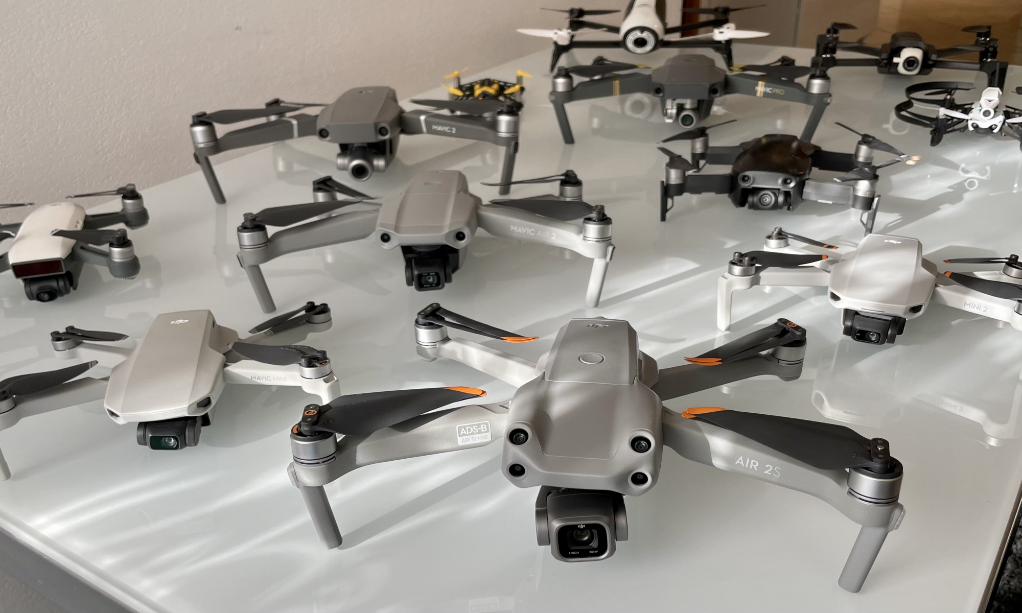
Here all supported Drones:

  • Mavic Mini
  • Mavic Mini 2
  • Mavic Mini SE
  • Mavic Air
  • Mavic Air 2
  • Mavic Air 2S
  • Mavic 2 Pro
  • Mavic 2 Zoom
  • Mavic 2 Enterprise
  • Mavic 2 Enterprise Dual
  • Mavic Pro
  • Mavic Pro Alpine
  • Mavic Pro Platinum
  • Spark
  • Phantom 3 series
  • Phantom 4 series

Previous Update 3.10

Uploading Flight Logs to AirData UAV

Overview

Every professional drone pilot understands the importance of having good quality post-flight logs at their disposal at all times.

They serve not only as analytical data to understand the events that unfolded during flight, but also as historical record of flights in compliance with regulations and predictive maintenance of onboard components & batteries.

How to configure log synchronization with AirData UAV

to start enter the flight logs section from the main screen of the app..

tap on settings…

enter your AirData upload token and that’s it

where retrieve the upload token

go to airdata.com and log in, the click on “My account”

click on Auto Upload Token

here you AirData Upload Token

If you are logged in on airdata.com you can just follow this link to go the Upload token page: https://app.airdata.com/main?a=account&apage_id=auto_upload_token

How upload Flight Logs to AirData.com

once your upload token is configured, simply tap the upload button to sync the desired logs with airdata.com

Maven 3.8 – Elevation API

Maven app has just been updated again.
In this update we have included 2 new features that will greatly help you plan your mission
1) Above ground (altitude option)
2) define Mission “by Flight”

both new functions will help you define the mission where the heights of the terrain or the object you want to shoot are unknown to you.

Above the Ground:

(beta preview, the actual version my be different)

The elevation information is taken from different internet database

Main Elevation Data Provider:

DEM Net Elevation API ( https://elevationapi.com )

using these digital elevation models:

NASADEM – https://doi.org/10.5067/MEaSUREs/NASADEM/NASADEM_HGT.001\

RTM_GL1 OpenTopography – https://opentopography.org/

“by Flight” Tutorial

Complete Maven 3.8 change log:

  • Added “Above The Ground” altitude option
  • Added the ability to save waypoints directly from the drone position
  • Added “+” annotation before first waypoint and after the last waypoint for faster mission modification
  • Added a label with the distance to the POI in the waypoint settings
  • Added a button to change the map from standard images to satellite images in mission settings
  • Improved the responsiveness of the app when adding waypoints
  • Increased responsiveness when selecting waypoint with a tap
  • Fixed an issue that can sometimes cause too loud sound to be played when a waypoint is added
  • Fixed an issue that caused the drone to remain hovering at the first waypoint in some situations

Maven 3.6.5 – Precision

Maven just got updated! Improvements in various aspects and parameters for missions to waypoints and more. The complete change log after this video on the update’s tasty feature, hey! also take a look on our updates road map

Maven 3.6.5 highlights

Maven 3.6.5 change log:

-Improved positioning accuracy in waypoint mission planning (and execution) :

  • now when you drag a waypoint or a POI on the screen a magnifying glass appears which shows the precise point under it
  • in the waypoint or POI details panel there is now a zoomed mini map showing the precise positioning
  • in the waypoint details you can now manually change the coordinates (latitude and longitude) of the waypoint
  • reduced the minimum distance between two consecutive waypoints to 0.5m (1.6ft) before was 3m (9.8ft)
  • minimum distance between waypoints now calculated in 3D (which means that now you can place a waypoint exactly above the previous one, changing only the altitude)
  • increased the accuracy of the drone positioning when it has to stop at a waypoint, now the position reached is considered valid only when the drone is less than 0.3m (1ft) from the coordinates of the waypoint, previously it was 1m (3ft)

-Increased the maximum speed that can be set in waypoint missions to 15m/s (before it was 10m/s) note: not all drones supported by the app can reach this speed during missions, check user manual for more details.
-Reduced the minimum speed that can be set to 0m/s (0.1m/s for virtual stick mission) before the minimum was 1m/s.

-Increased maximum radius of curvature in waypoints to 500m (1650ft), up from 30m (100ft).

-Enables the ability to manually rotate (yaw) the drone during missions with drones that perform virtual stick missions (mavic mini and air 2) (it was already possible with other drones).

-Added full support to the spark drone

-Eliminated the English manuals inside the app, they are now available online (link in the manuals section of the app)

-Added link to manuals in Serbian language (thanks Milan for the translation)

-Fixed an issue that VPG could not work properly in VR mode

-Fixed an issue that could prevent some missions from loading correctly in the drone

updates RoadMap:

Maven 3.7

  • more actions on the waypoint, this also means more types of actions and more flexibility
  • more points of interest, the number of POIs is now limited to 3 for each mission will be increased significantly
  • Import missions from Litchi, the supported format will be CVS which can be exported from the Litchi mission HUB.

Maven 3.8

  • create mission by actually flying the drone, you can fly the drone and save waypoints (with all the parameters of rotation (yaw) and inclination of the camera)
  • follow me, this much requested feature will be added as a new virtual coopilot capability

note: the road map is not law, and may be subject to change at any time at our discretion. the timing for the completion of scheduled updates is also variable based on many parameters, we want to keep the level of quality and stability of the app high so we will take the necessary time.

Maven 3.6 – Copilot

Maven 3.6 is available on the app store! It brings improvements to all the functions of the app and introduces a whole new function: the virtual co-pilot! Watch the video to find out what it is and how to use it! Check also the complete change log after the video

-Virtual Copilot

a totally new feature to the app, especially useful for drones without native Point of Interest functionality (e.g. Mavic Mini) choose a point on the map, then ask the copilot to control the Yaw Rotation and the camera to look at that point while you are free to manually fly the drone.

The copilot has also more advanced skill such as “orbit” and “cable cam” , check the included manual.

The copilot will open doors to great shots even to inexperienced pilots!

-Waypoint Mission Improvement:

1)Mission trimnow you can choose which waypoint to start and end the mission from without deleting waypoints

2) Interval photosnow you can take photos at intervals between waypoints, based on time or distance

3)rewrote the virtual stick algorithm again for drones without native waypoint mission capabilities (mavic mini and mavic air 2) you will see a big improvement in smooths in speed and direction changes

– Faster head tracking speed option in VR mode

-Improvement of the user interfacenow camera controls can be minimized for a less cluttered interface

-Added device charging options for remotes that allow it

-Fixed a bug where the corner radius of the second waypoint could not be saved in some situations